Showing posts with label drought. Show all posts

Tuesday, March 30, 2021

America's Megadrought and its Potential Impact on American Consumers

While we are distracted with the fear porn associated with the COVID-19 pandemic, a situation of great concern to the producers of our food is unfolding with very little meaningful recognition by the mainstream media, particularly given its seriousness.


Here is a recent news item from Fox6 in Milwaukee:


Let's look at the actual data from the United States Drought Monitor for the western United States:


Here is a table showing the data behind the map:


In mid-March 2021, 20.61 percent of the western United States was considered to be in an exceptional drought situation, down from 22.16 percent at the end of December 2020 but up from 0 percent in March 2020.  In total, 39.49 percent of the western United States is considered to be in an extreme or exceptional drought, down from 46.63 percent just prior to Christmas 2020 but, again up substantially from 0 percent in March 2020.


Here is the latest drought summary for the western United States with my bolds:


"A slight expansion of severe drought (D2) was made to northeast Montana, based on 90-day SPI (standardized precipitation index) and soil moisture below the 10th percentile. These low soil moisture conditions are related to the lack of snowfall this winter. In contrast to the northern high Plains, snow water content is running close to average for late March and led to the elimination of abnormal dryness (D0) across south-central Montana. Since parts of western Arizona and southeast California have received little to no precipitation during the past two month, D3 (extreme) and D4 (exceptional) drought were slightly increased. This expansion of D3-D4 was supported by 9-month SPI values which covers the failed 2020 monsoon and this past winter. An expansion of D2 (severe) and extreme (D3) drought across parts of southern California was based on large water year to date precipitation deficits and 6-month SPI values. No other changes were made at this time to the remainder of California as 6 to 12 month SPIs generally support the current depiction and snow water content is running near two-thirds of average for the Sierra Nevada Mountains. During subsequent weeks, the drought depiction will be reassessed across California. Although much of the precipitation this past week fell along the coast or over the Cascades, a reassessment of longer term SPIs dating back 6 to 12 months supported removal of the D2 (severe) drought in southwest Oregon. Due in part to recent high-elevation snow and rainfall during the past two weeks, a slight decrease in D3 (extreme) and D4 (exceptional) drought was made to northern and northeast New Mexico. However, widespread D4 persists across southeast New Mexico where dust storms have been quite frequent this month and soil moisture remains in the lowest one percentile."


Let's look at the drought situation for the entire continental United States.  Here is a map showing the drought situation for March 24, 2020:


Here is what the drought situation looked like by the beginning of August 2020:


Here is what the drought situation looked like at the end of December 2020:


Lastly, here is what the drought situation looks like now:


Given that, historically speaking, drought conditions in the continental United States tend to be very low during the early part of the year, the fact that an extreme drought is currently plaguing the west is of great concern for food producers of all types and for consumers and, given the current stresses in the world's supply chains, we may well find that significant food price inflation will result in even greater financial strain on American farmers and for American and Canadian consumers.


Sunday, February 2, 2014

Dry and Thirsty in California

According to the USDA Drought Monitor, the southwestern United States, particularly California, is suffering from a prolonged and rather exceptional drought.  Here is a map showing drought conditions across the United States with darker areas showing drought intensity:


Here is a closeup of California:


In total, 98.57 percent of the state is suffering from abnormally dry conditions or worse, up from 65.8 percent last year at the same time.  A shocking 67.1 percent of the state is suffering from an extreme or exceptional drought, up from zero percent last year at the same time, however, approximately 22 percent of the state was suffering from a severe drought in January 2013. 

Let's look at three details:

1.) The Central Sierra Snow Lab, located in the Sierra Nevada near Donner Pass reports only 8 inches of snow on the ground, the lowest snowpack for this point in January since 1946.

2.) In the D4 (exceptional drought) drought area between Monterey and Bakersfield, wells have run dry with municipalities having to drill deeper wells.  As well, rangelands have no grass cover, prompting farmers to sell off livestock.

3.) The State Water Project, part of the California Department of Water Resources which supplies water for 25 million Californians and 750,000 acres of irrigated farmland, announced that it has taken action to conserve the state's water resources, cutting allocations to farmers and people in the state's cities and towns.  Storage in the state's key reservoirs is lower than at this time in 1977, one of the two previous driest years on record.  Lake Oroville in Butte County is at 36 percent of its capacity (compared to an average of 55 percent) and San Luis Reservoir is at a mere 30 percent of its capacity (compared to an average of 39 percent).  Never before has the State Water Project announced a zero allocation to all 29 public water agencies that buy water from it. 

Here is a map showing the response of vegetation to the drought:


A total of 26.6 percent of the state shows moderate to extreme vegetation stress related to the current drought conditions as measured by the VegDRI or Vegetation Drought Response Index which is based on remote sensing, climate and biophysical data.  Last year at this time, only 14 percent of the state showed similar conditions.

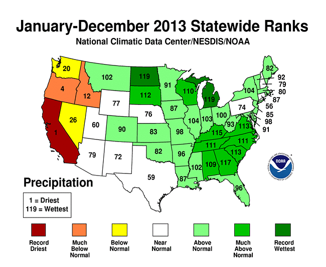
Data from the National Oceanic and Atmospheric Administration (NOAA) shows us how this problem for California came about.  Here is a map showing the states ranked by the amount of precipitation they received during 2013:


California was the driest state overall and had the driest year on record, receiving only 7.38 inches of precipitation, 15.13 inches below average and 2.42 inches below the previous record dry year of 1898.  

Here is a map showing the states ranked by their average temperature during 2013:


California was the only state that had temperatures that were much above normal during 2013 and it was the warmest state in the continental United States.  California tied its twelfth warmest year with a statewide temperature that was 1.4 degrees Fahrenheit above average. 

Let's close by looking at the definition of climate:

"Climate is the average course or condition of the weather at a place usually over a period of years as exhibited by temperature, wind velocity, and precipitation."


Certainly, California's warm and extremely dry weather cannot be attributed to climate change since weather is a short-term phenomenon, however, since climate is defined by the average condition of the weather over a period of time, eventually all of the current data will become part of the climate record.  When enough of these anomalous conditions add up and become part of the average, eventually, it will become apparent whether climate is changing or we're just having a few years of anomalous weather.  Unfortunately, by then, it will be long past too late to do anything about it.  With California producing nearly half of the fruits, vegetables and nuts grown in the United States, the current drought is going to have a wide impact in any case.